Theme : Government Policies ; Environment & Ecology
Paper : GS - 2, GS - 3
TABLE OF CONTENT
- Context
- Importance of ANI
- Geography of ANI
- Objections on India developing ANI
- Rationale behind developing ANI
- Countering China
- Road Ahead
Context : The Andaman and Nicobar Islands (ANI) are in the news as the union government proposes a slew of infrastructure projects to boost business and tourism on the islands, and conservation groups are on the warpath.
Importance of ANI :
- Oceanic outpost: The ANI is an oceanic outpost for continental India.
- Facilitates unique surveillance: With a critical vantage location overlooking the ten-degree and six-degree channels (through which a vast majority of cargo and container traffic in the eastern Indian Ocean transits), the islands give India a unique surveillance and maritime interdiction capability.
- Strategically important: The ANI is a vital ‘staging post’ for maritime operations, and a hub for logistics, providing operational turnaround for Indian warships and aircraft deployed in the Andaman Sea.
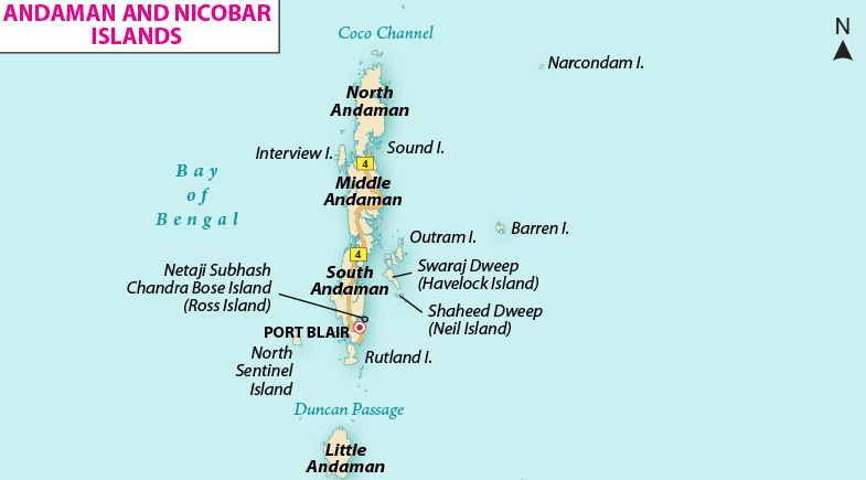
Geography of ANI :
- Location: Located between 6° and 14° North Latitude and 92° and 94° East Longitude lie the Andaman and Nicobar Islands, a union territory in India.
- Two groups of Island: It consists of two groups of islands. The islands located north of 10° north latitude are known as Andaman while islands located south of 10° north latitude are called Nicobar.
- The Andamans: More than 300 islands make up the Andamans. North, Middle, and South Andaman, known collectively as Great Andaman, are the main islands;
- The 10- degree channel: The 10-degree channel which is about 145 km long separates Little Andaman in the south from the Nicobar Islands.
- The Nicobars: The Nicobars consists of 19 islands. Among the most prominent is Car Nicobar in the north; and Great Nicobar in the south. About 90 miles to the southwest of Great Nicobar lies the northwestern tip of Sumatra, Indonesia.
- Formation: Both the Andaman and Nicobar groups are formed by the above-sea extensions of submarine ridges of mountains and are a part of a great island arc. The highest peak is 2,418 feet at Saddle Peak on North Andaman, followed by Mount Thuillier at 2,106 feet on Great Nicobar and Mount Harriet at 1,197 feet on South Andaman. Barren island, the only known active volcano in south Asia lies in the Andaman Sea. In the late 20th and early 21st centuries, there were volcanic eruptions on Barren Island.
- Andaman Terrain: Formed of sandstone, limestone, and shale of Cenozoic age, the terrain of the Andamans is rough, with hills and narrow longitudinal valleys. Flat land is scarce and is confined to a few valleys.
- Nicobar Terrain: The terrain of the Nicobar is more diverse than that of the Andamans. Some of the Nicobar Islands, such as Car Nicobar, have flat coral-covered surfaces with offshore coral formations that prevent most ships from anchoring. Other islands, such as Great Nicobar, are hilly and contain numerous fast-flowing streams.
- Great Nicobar is the only island in the territory with a significant amount of fresh surface water.
- The climate of the Andaman and Nicobar Islands is tropical but is moderated by sea.
Objections on India developing ANI :
- Perspective of India’s diplomatic community:When India first began developing the ANI in the 1980s, the defense and foreign policy establishments were not entirely in agreement.
- India’s diplomatic community opposed the militarization plan, arguing that turning the islands into a strategic-military garrison would weaponize the littorals, an outcome unlikely to sit well with India’s maritime neighbors.
- Neighbor’s apprehensions: Indonesia and Malaysia were apprehensive that India would use its military facilities on the Andamans to dominate its region, and project power east of Malacca.
Rationale behind developing ANI :
- To counter China’s belt and road Initiative: New Delhi also needs to counter China’s Belt and Road Initiative. The manner of China’s development of infrastructure projects in the Bay of Bengal suggests that it seeks both economic leverage and strategic prowess in South Asia.
- Countering China Dual use facilities: By some accounts, China is looking for military access to Chinese-built facilities in the Bay of Bengal. Beijing, reportedly, is on a drive to create ‘dual-use’ facilities that have both commercial and military applications.
Countering China :
- By expanding military presence in BOB: One way for India to counter China’s forays in the Bay of Bengal would be to expand Indian military presence in the littorals. The process is already underway
- By turning islands into logistic support facilities for navies: The other way for India to counter China is to develop its island territories in the eastern Indian Ocean and offer military facilities therein for logistics support to navies from friendly Quad countries.
Road Ahead :
- New Delhi cannot afford to ignore the ecological implications of infrastructure development on the islands, in particular, the proposal for a container terminal at Campbell Bay on the Great Nicobar Island.
- The project entails the mass culling of forests and could take a toll on the region’s delicate ecological balance.
- New hotels, resorts, and a trans-shipment port could upend decades of conservation efforts.
FAQs :
1. What is the location of ANI ?
Answer : Located between 6° and 14° North Latitude and 92° and 94° East Longitude lie the Andaman and Nicobar Islands, a union territory in India.
2. What is the 10 degree Channel ?
Answer : The 10-degree channel which is about 145 km long separates Little Andaman in the south from the Nicobar Islands.